|
| Indian Brook Hopkinton State park |

|
| west of bridge 9/14/05 |
| Indian Brook Hopkinton State Park |

|
| east of bridge 9/14/05 |
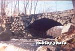
| Rte 85 Bridge Soutbhorough, MA |

|
| 1999 shot of river |
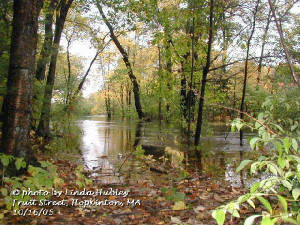
| Fruit Street, Hopkinton, MA west of bridge |

|
| August 1999 |
| Fruit Street Hopkinton, MA USGS Habitat survey |

|
| Site 9/14/05 |
| Howe Street Ashland, MA |

|
| USGS Habitat survey 9/14/05 |
|
 |
|
|
|
|
|
| Indian Brook, Hopkinton State Park |

|
| full 10/20/2005 |
| Indian Brook Hopkinton State Park |

|
| East of bridge 10/20/2005 |
| Rte 85 bridge Southborough, MA |

|
| 10/16/05 |
| Fruit St. Hopkinton, MA west of bridge |
|
| 10/16/05 |
| Fruit Street Hopkinton, MA USGS Habitat survey |

|
| Site 10/16/05 |
| Howe Street Ashland |

|
| Habitat survey site 10/27/05 |
|
|
|
|
|